Facets and scales in river restoration: Nestedness and interdependence of hydrological, geomorphic, ecological, and biogeochemical processes

4 facets river

Authors

Lina E. Polvi, Lovisa Lind, Henrik Persson, Aneliza Miranda-Melo, Francesca Pilotto, Xiaolei Su, Christer Nilsson

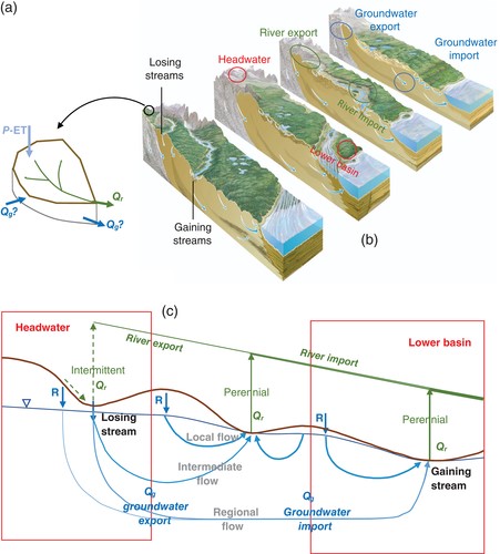
Although river restoration has increased rapidly, observations of successful ecological recovery are rare, mostly due to a discrepancy in the spatial scale of the impact and the restoration. Rivers and their ecological communities are a product of four river facets—hydrology, geomorphology, ecology and biogeochemistry—that act and interact on several spatial scales, from the sub-reach to the reach and catchment scales. The four river facets usually affect one another in predictable pathways (e.g., hydrology commonly controls geomorphology), but we show that the order in which they affect each other and can be restored varies depending on ecoregion and hydroclimatic regime. Similarly, processes at different spatial scales can be nested or independent of those at larger scales. Although some restoration practices are dependent of those at higher scales, other reach-scale restoration efforts are independent and can be carried out prior to or concurrently with larger-scale restoration. We introduce a checklist using the four river facets to prioritize restoration at three spatial scales in order to have the largest positive effect on the entire catchment. We apply this checklist to two contrasting regions—in northern Sweden and in southern Brazil—with different anthropogenic effects and interactions between facets and scales. In the case of nested processes that are dependent on larger spatial scales, reach-scale restoration in the absence of restoration of catchment-scale processes can frankly be a waste of money, providing little ecological return. However, depending on the scale-interdependence of processes of the river facets, restoration at smaller scales may be sufficient. This means that the most appropriate government agency should be assigned (i.e., national vs. county) to most effectively oversee river restoration at the appropriate scale; however, this first requires a catchment-scale analysis of feedbacks between facets and spatial scale interdependence.

Bloom announcement: An early autumn cyanobacterial bloom co-dominated by Aphanizomenon flos-aquae and Planktothrix agardhii in an agriculturally-influenced Great Lakes tributary (Thames River, Ontario, Canada)

HABs_CA

Authors

R. Michael McKay, Thijs Frenken, Ngan Diep, William R. Cody, Sophie Crevecoeur, Alice Dove, Kenneth G. Drouillard, Xavier Ortiz, Jason Wintermut, Arthur Zastep

The Thames River is a priority tributary of the Lake Erie watershed, as identified in Annex 4 of the Great Lakes Water Quality Agreement. The river flows into Lake St. Clair in southwestern Ontario with land use in the watershed dominated by row crop agriculture.

In September 2019, a cyanobacterial bloom was observed in the lower Thames River. First reports of the bloom were communicated on September 23 by the Lower Thames Valley Conservation Authority to the Ontario Ministry of the Environment, Conservation and Parks (MECP) with synoptic sampling by our collaborative team commencing immediately and continuing through October 15 along a 50 km stretch of the river extending from Thamesville, ON to Prairie Siding, ON. Additional daily sampling was provided by autosamplers located at the river mouth and at Thamesville.

Impacts of a large river-to-lake water diversion project on lacustrine phytoplankton communities

Phytoplankton hydrology

Authors

Jiangyu Dai, Shiqiang Wu, Xiufeng Wu, Xueyan Lv, Bellie Sivakumar, Fangfang Wang, Yu Zhang, Qianqian Yang, Ang Gao, Yuhang Zhao, Lei Yu, Senlin Zhu

Allochthonous inputs of species and nutrients and hydrodynamic disturbance induced by water diversion projects are two critical factors of ecohydrological effects in eutrophic lakes. However, identification and quantification of potential contributions of allochthonous inputs and physicochemical habitat shifts to variations in phytoplankton communities remain challenging. The present study addresses this issue with a study of the Water Diversion from the Yangtze River to Lake Taihu in China. To explore the effects and contributions of seasonal water diversion activities on lacustrine phytoplankton communities, the comparative analysis was conducted to compare the biotic and abiotic variables between the water diversion and non-diversion periods in different seasons. The results showed that seasonal water diversion activities, in addition to significantly reducing organic pollutant concentrations, definitely increased the average concentrations of nitrate and phosphorus in the Gonghu Bay. Compared with the results in the Gonghu Bay on the non-diversion days, phytoplankton diversities increased and the community compositions were altered, with the Bacillariophyta species and non-Microcystis Cyanophyta species dominating in the Gonghu Bay on the water diversion days in different seasons. The venn diagram analysis showed that the highest potential contribution of the allochthonous species to the increase in phytoplankton diversity in the Gonghu Bay on the water diversion days was about 15.8%. The physicochemical habitat disturbance induced by the water diversion contributed about 12% to 31.3% of the phytoplankton diversity and 23.3% to 31.3% of the phytoplankton community variations in the Gonghu Bay. The allochthonous phytoplankton species may contribute directly to the lacustrine phytoplankton community variations. However, due to the high loads of nutrients from inflow rivers, positive effects of water diversion shaping the phytoplankton communities were always short-term. Pollutant control and multi-objective operation, considering flood control, water supply, and water environment improvement, are indispensable for the long-term management of water diversion projects.

Dynamic transfer of soil bacteria and dissolved organic carbon into small streams during hydrological events

DOC+Bacteria

Authors

Florian Caillon & Jakob Schelker

Small headwater streams interlink catchment soils with the river network. As water makes its way from the hillslopes to the stream, it may transport dissolved organic carbon (DOC) and potentially soil microbes into stream water. In this study, we aimed at quantifying the dynamic transfer of DOC and microbial life, namely bacteria from catchment soils into streams. We hypothesized that increased soil saturation enhances the lateral inflow of bacteria and DOC into streams. To address this hypothesis, we sampled six first order streams and three soil transects at two different depths located within the pre-alpine Oberer Seebach (OSB) catchment in Austria over a duration of 2 years. We found a strong variation in DOC concentrations (range 0.4–5.6 mg L−1) and bacterial abundances (range < 500,000–3,863,000 cells mL−1) measured by flow-cytometry. The highest values of DOC and bacterial cells occurred during high flow events. DOC concentration and bacterial abundance were correlated across all streams and seasons. In soils, DOC ranges were higher and were also correlated with bacterial abundance, while DOC concentrations were ∼ 10 times higher per bacterial cell than in streams. Overall we show that soils provide a dynamic inflow of bacteria and DOC to first order streams. Most probably, this results in a dynamic and reoccurring inoculation of small streams from catchment soils during runoff events. We propose that this dynamic microbial inoculation of small streams is potentially relevant for microbial community dynamics of downstream receiving waters.


Influence of land use and hydrologic variability on seasonal dissolved organic carbon and nitrate export: insights from a multi-year regional analysis for the northeastern USA

Land Use C+N Export

Authors

Erin Seybold, Arthur J. Gold, Shreeram P. Inamdar, Carol Adair, W. B. Bowden, Matthew C. H. Vaughan, Soni M. Pradhanang, Kelly Addy, James B. Shanley, Andrew Vermilyea, Delphis F. Levia, Beverley C. Wemple, Andrew W. Schroth

Land use/land cover (LULC) change has significant impacts on nutrient loading to aquatic systems and has been linked to deteriorating water quality globally. While many relationships between LULC and nutrient loading have been identified, characterization of the interaction between LULC, climate (specifically variable hydrologic forcing) and solute export across seasonal and interannual time scales is needed to understand the processes that determine nutrient loading and responses to change. Recent advances in high-frequency water quality sensors provide opportunities to assess these interannual relationships with sufficiently high temporal resolution to capture the unpredictable, short-term storm events that likely drive important export mechanisms for dissolved organic carbon (DOC) and nitrate (NO3–N). We deployed a network of in situ sensors in forested, agricultural, and urban watersheds across the northeastern United States. Using 2 years of high-frequency sensor data, we provide a regional assessment of how LULC and hydrologic variability affected the timing and magnitude of dissolved organic carbon and nitrate export, and the status of watershed fluxes as either supply or transport controlled. Analysis of annual export dynamics revealed systematic differences in the timing and magnitude of DOC and NO3–N delivery among different LULC classes, with distinct regional similarities in the timing of DOC and NO3–N fluxes from forested and urban watersheds. Conversely, export dynamics at agricultural sites appeared to be highly site-specific, likely driven by local agricultural practices and regulations. Furthermore, the magnitude of solute fluxes across watersheds responded strongly to interannual variability in rainfall, suggesting a high degree of hydrologic control over nutrient loading across the region. Thus, there is strong potential for climate-driven changes in regional hydrologic cycles to drive variation in the magnitude of downstream nutrient fluxes, particularly in watersheds where solute supply and/or transport has been modified.

Are catchments leaky?

leaky watersheds.png

Author

Ying Fan

Catchments, generally understood as the drainage areas of low‐order streams, are often regarded as closed hydrologic entities; that is, precipitation (P) minus evapotranspiration (ET) over a catchment equates stream outflow (Q r). Here, we review evidence that catchments can be leaky due to groundwater outflow or inflow across topographic divides, based on catchment mass balance across a continent and several site‐based studies across the globe. It appears that a catchment is more likely to be leaky with the combination of the following factors: small catchment size, positioned at either the high or low end of a steep regional topographic and climatic gradient, underlain by deep permeable substrates that extend beyond the study catchment, and in drier climate or dry seasons and droughts. Catchment leakage has hydrological, geochemical, and ecological implications. Thus, catchments are best framed as semiclosed hydrologic units perched on top of a larger, regional hydrogeological system with no real boundaries regarding the movement of water and solutes.

A complex network analysis of Spanish river basins

CNA Spain

Authors

R. Rodríguez-Alarcóna, S. Lozano

This paper carries out a study of Spanish river basins for the period 2008–2014 using complex network analysis (CNA) tools. The purpose is to gain insight into the structure and characteristics of the national hydrological system with an emphasis on the interconnectivity between the different river basins and the extent to which the current IBT can mitigate the rainfall imbalances of the country, particularly in a scenario of climate change. Apart from the size of the corresponding catchment areas, data on water demand for irrigation, industrial and municipal water supply, historical catchment inflows, reservoir capacity and historical levels, interbasin transfer infrastructures and historical interbasin transfer (IBT) flows, and ocean discharges were collected. A weighted directed network is built with all this information and a number of CNA characterization measures. It has been found that the system has a two-tier structure with a few river basins (hubs) that supply IBT flows to a relatively large number of receiver river basins. Some of those receiver river basins have incoming links from more than one source river basin. This diversification of IBT sourcing is necessary since the availability of water for IBT from a single river basin is not guaranteed. The CNA results also indicate that the IBT infrastructure has been designed to supply water from the river basins with surplus reservoir capacity to river basins with water deficits. The community structure of the system has also been determined with some groups of river basins forming separate, self-sufficient subsystems and other communities minimally connected by IBT links. It can be concluded that the topology and characteristics of the network are a consequence of the imbalances created by the varying climatic conditions of the river basins, the water storage capacity provided by the existing reservoir infrastructure, the geographical and orographic constraints of the country and the high cost of establishing links between neighbouring river basins.

Microbial mat contribution to the formation of an evaporitic environment in a temperate-latitude ecosystem

Evaporite

Authors

Vanesa Liliana Perillo, Lucía Maisano, Ana María Martinez, Isabel Emma Quijada, Diana Graciela Cuadrado

An evaporitic environment is characterized by having high salinity, climatic, and hydrological factors that promote a negative water balance; however, biological factors may also influence their development. Modern coastal flat Paso Seco (40°33′S; 62°14′W) is located in a semi-arid region with low precipitation and dry winds coming mainly from the NW. The site is an old tidal channel, which nowadays behaves like a shallow coastal saline-like basin, separated from the sea by a sand barrier, which the sea periodically overcomes, flooding the flat with eventual water evaporation. Microbial mats of up to 1 cm thick colonize the sandy sediments of this evaporitic environment. Water samples were taken during five field trips (2017–2018) from interstitial water of the flat, a tidal creek that crosses the flat, and two shallow tidal depressions (TDs) within the flat with different degrees of evaporation. In comparison to the sea, the maximum salinity values measured in Austral spring (September 2017) in the tidal creek were doubled, tripled in interstitial water, and 5.9 to 8 times higher in TDs. Ionic concentration denotes that evaporite chemical divides are followed as water evaporates, corresponding to the presence of CaCO3, gypsum and halite found in TDs. On-site permeability of microbial mat-covered surfaces presented semi-pervious properties. Microbial mat presence is condition for CaCO3, gypsum, and halite precipitation as they allow for water retention and its consequent evaporation due to the impermeability they confer to the sedimentary surface. Thus, microbial mats are a biological factor affecting the development of an evaporitic environment.

Application of remote sensing to water environmental processes under a changing climate

RM Global

Authors

Xintong Cui, Xiaoyu Guo, Yidi Wang, Xuelei Wang, Weihong Zhu, Jianghong Shi, Chunye Lin, Xiang Gao

Remote sensing, as a crucial method to obtain information on water environmental processes, has become a major source of data, particularly of water environment and water resources, which are sensitive to global climate change. The bibliometric analysis provided here shows the research characteristics and developments of remote sensing-based observations of water environmental processes under a changing climate from 2000 to 2018. Visualized knowledge mapping is introduced to investigate the development status, scientific collaboration, involved disciplines, research hotspots and emerging trends of this field. The breadth and depth of remote sensing application in water environmental process studies have improved significantly as the number of related publications rose at an average annual growth rate of 15.97% in the 21st century. The United States and China were the leading contributors with the largest number of publications and all of the top 15 most active institutions. In addition, this field is a highly interdisciplinary field that covers a wide range of interests, from water resources to environmental science, geology, engineering, ecology, and agriculture. The application of remote sensing technology has significantly promoted the estimation of evapotranspiration and soil moisture, thereby offering a more complete perspective to the understanding of the water cycle. Additionally, climate change and its complex interactions with water environmental processes, including the occurrence of drought events, are of great significance and require special attention.

Observations and modeling of the surface seiches of Lake Tahoe, USA

Tahoe Seiche

Authors

Derek C. Roberts, Heather M. Sprague, Alexander L. Forrest, Andrew T. Sornborger, S. Geoffrey Schladow

A rich array of spatially complex surface seiche modes exists in lakes. While the amplitude of these oscillations is often small, knowledge of their spatio-temporal characteristics is valuable for understanding when they might be of localized hydrodynamic importance. The expression and impact of these basin-scale barotropic oscillations in Lake Tahoe are evaluated using a finite-element numerical model and a distributed network of ten high-frequency nearshore monitoring stations. Model-predicted nodal distributions and periodicities are confirmed using the presence/absence of spectral power in measured pressure signals, and using coherence/phasing analysis of pressure signals from stations on common and opposing antinodes. Surface seiches in Lake Tahoe have complex nodal distributions despite the relative simplicity of the basin morphometry. Seiche amplitudes are magnified on shallow shelves, where they occasionally exceed 5 cm; elsewhere, amplitudes rarely exceed 1 cm. There is generally little coherence between surface seiching and littoral water quality. However, pressure–temperature coherence at shelf sites suggests potential seiche-driven pumping. Main-basin seiche signals are present in attached marinas, wetlands, and bays, implying reversing flows between the lake and these water bodies. On the shallow sill connecting Emerald Bay to Lake Tahoe, the fundamental main-basin seiche combines with a zeroth-mode harbor seiche to dominate the cross-sill flow signal, and to drive associated temperature fluctuations. Results highlight the importance of a thorough descriptive understanding of the resonant barotropic oscillations in any lake basin in a variety of research and management contexts, even when the magnitude of these oscillations tends to be small.